Hi Everyone:
Barb & I are back on the road after a busy week in the Mount Vernon Washington area. While there we visited with Barb's brother and sister in law Rusty & Diane, Barb's cousin and her husband Trudy & Greg and my cousin & his wife Ron & Karen. Barb & I really enjoyed our visit with each of you. We thank y'all being our tour guides to some very interesting & beautiful locations. Barb & I would like to thank Ron & Karen for the delicious dinner during our too short but very enjoyable of a visit with y'all.
We have stopped in Pendleton Oregon for a couple of nights on our way to our next destination, the National Parks in Southern Utah. I will make a concentrated effort to catch up on Da Road Trip Blog depending on the strength of the wi-fi signals in the areas we are in.
This is our visit & exploration of Lassen Volcanic National Park. Barb & I were there on May 25th. This was two days after the 5.7 magnitude earthquake hit nearby. We were staying about 50 miles from the epicenter. The volcano is about 20 miles from the epicenter.
Lou & Barb
One of Many Streams From the Snow Melt. Still Plenty of Snow on the Volcano
"Sulphur Works" Hydro Thermal Vent. Yellow Coloring On Rocks in this area are From the High Concentration of Sulphur Gasses Spewing from the Vents in this Area.
Notice the Instrument Next to Vent. Scientist are Monitoring the Vents to see if the Recent Earthquake has Caused any Changes Within the Volcano.
Boiling Hydrothermal Pool
Another Boiling Hydrothermal Pool
One of the Many Steam Vents
Lassen Peak, Elevation 10,457 ft.
Enjoying Some of the Beauty
Frozen Emerald Lake, Above 8,000 ft.
Barb's Creation, One of Her Many Talents
Damn, We Really Wanted to Hike This Trail
Roads Highest Elevation, 8,512 ft.
Frozen Lake Helen
Mountain Stream
Summit Lake Elevation 7,000 ft
Dersch Meadows
Lassen Peak
Lassen Volcano Last Eruption in May 1914 Launched three years of Sporadic Outbursts. In the Largest on May 22, 1915, the Peak Blew a Huge Mushroom Shaped Cloud of Ash Over 30,000 ft. This Eruption Profoundly Altered the Surrounding Area. Lassen Volcano is on the Southern End of the Cascade Range, Which is a Chain of Active Volcanoes that Stretch North to Mount Garibaldi in British Columbia.
This Entire Forrest on the next few Pictures has Grown here Since the 1915 Eruption that Devastated the Entire Area
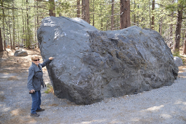
All of the Boulders & Rocks in This Area were Thrown Here Over Three Miles During the 1915 Eruption
"Hot Rocks" This Bolder was Still Sizzling in Water Over 40 Hours After the Eruption When Discovered by B. F. Loomis Who Came to see the Results of the Eruption.
Chaos Crags, Elevation 8,530 ft.
After leaving Lassen Volcanic National Park to the north Barb & I Visited McArthur-Burney Falls State Park. There is a waterfall there, Burney Falls, that will just simply blow you away.
Lush Foliage From Mist of the Falls


No comments:
Post a Comment